
Storms and Heat This Week In Disney World
The unsettled weather from this past weekend continues this week in Disney World as temperatures rise. Get the details on timing, when we should see rain chances decrease, and whether we can expect any relief from the heat.
Weather Forecast Discussion

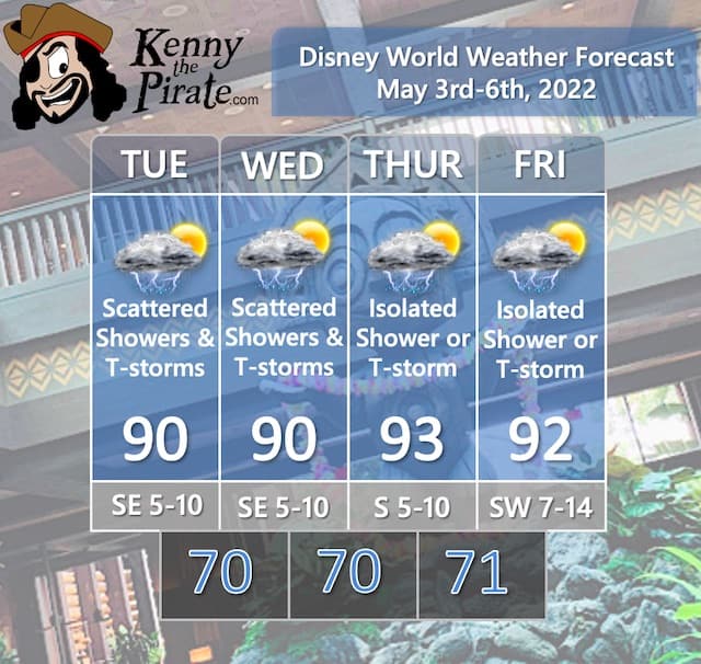
The unsettled weather that brought showers and thunderstorms to Central Florida over the weekend will continue this week, especially on Tuesday and Wednesday. A weak mid-level trough is responsible for the increased moisture, and that feature will slide offshore by later in the week.
The highest shower and thunderstorm chances will be on Tuesday and Wednesday in the afternoon and evening as daytime heating adds to the instability in the atmosphere. Be prepared to dodge a few showers and thunderstorms each day if you are in the theme parks. As we saw over the weekend, any storms that do develop can bring heavy downpours and localized flooding. By Thursday and Friday, NW flow aloft will dry the airmass out a bit leading to only isolated shower and thunderstorm chances.
Not lost in the rain discussion is the fact that this week will certainly be hot across Central Florida with highs near 90 on Tuesday and Wednesday and in the low 90's Thursday and Friday ahead of a frontal boundary. More on the frontal boundary in the "Look Ahead" below.
Severe Weather Chances For Florida
No Severe Weather is expected throughout the forecast period. The thunderstorms that may accompany the rain showers this week are expected to remain below severe criteria. The main story with any of those storms will be locally heavy downpours.
Remember that any thunderstorm can produce gusty winds, frequent lightning, and heavy downpours. Follow any warnings and cast member directions to take shelter.
Flight Impacts

This category is designed to point out any large-scale impacts on flights getting to and from Orlando. The struggles and impacts on the airline industry in the wake of the pandemic that led to flight cancellations have been well-documented. I'm focusing on the weather impacts.
We do have a storm system moving from the Midwest on Tuesday into the Mid Atlantic on Wednesday. The main story will be severe weather possible from across the Ohio Valley on Tuesday. With that said, I'm not expecting major large-scale delays from this system. It will be more localized. Check your flight status if flying out of or into these areas this week.
In terms of Orlando-area airports, there could be some minor delays with the shower activity on Tuesday and Wednesday. It does not look like a major issue but be advised that some delays are possible.
A Look Ahead

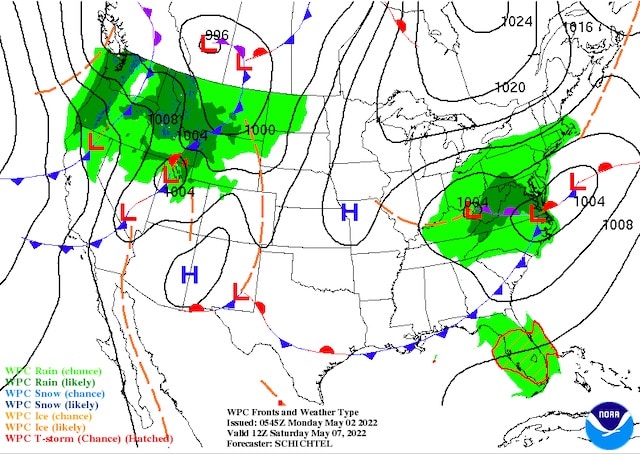
Looking ahead to the weekend, I will be watching an approaching frontal boundary that should set off some showers and thunderstorms Saturday and Sunday. This front will "cool" things down to the upper 80's Saturday but temperatures will rebound to around 90 degrees by Sunday and Monday.
The Saturday surface map is below showing the front approaching from the north as another low pressure heads off the Mid Atlantic coast.
Are you headed to Disney World this week? Will the showers affect your plans? Are you ready to deal with the heat? Let us know in the comments below or on Facebook!