
Severe Weather Possible This Week In Disney World
The weather outlook for March 22nd to 25th has some severe weather chances and a bit of a roller coaster ride of temperatures. Get the details on what to expect this week as another strong storm system moves across the United States.
Weather Forecast Discussion

High pressure will slide off the Southeast U.S. coast on Tuesday as a potent storm system moves from Texas into the Ohio Valley. In the Orlando area, Tuesday looks like a warm, dry day. It will be a bit breezy on Tuesday and Wednesday ahead of the storm system.
The cold front attached to this storm system will approach from the west and bring the chance of showers and thunderstorms late Wednesday and Thursday. More on the severe threat below, but heavy downpours are possible with these showers and thunderstorms.
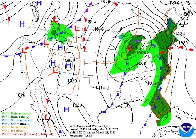
On the surface map below for Thursday at 7AM, you can see the front approaching the Florida peninsula with showers and thunderstorms ahead of it.
Showers and thunderstorms should come to an end on Thursday night. Behind the front, temperatures will be cooler on Friday with highs in the mid 70's. We could see a leftover shower or two, but conditions should be improving throughout the day.

Severe Weather Chances For Florida
First off, the good news is that Florida should not see anything close to the widespread severe weather affecting Texas into the Southeast U.S. However, there is the chance for some marginal severe weather in Orlando. On Wednesday, the main severe threat looks like it will be north of Orlando across the panhandle.
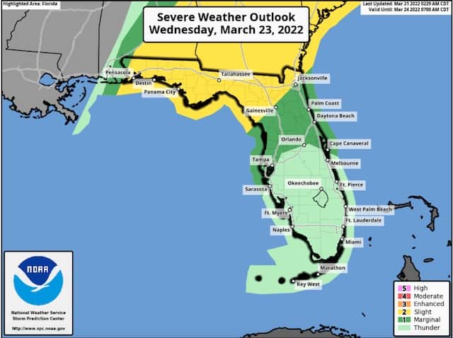
For late Wednesday night and Thursday the severe threat will shift to include Orlando, and my guess is that some isolated severe storms are possible. The bigger threat likely will be the heavy downpours possible. I will be sure to pass an update along on Wednesday and Thursday on my Twitter feed (see below) on where things stand with the severe threat.
While most storms are expected to remain below severe levels this week, remember that any thunderstorm can produce gusty winds, frequent lightning, and heavy downpours. Follow any warnings and cast member directions to take shelter.
Flight Impacts

I added this category recently to point out any large-scale impacts on flights getting to and from Orlando. The struggles and impacts on the airline industry in the wake of the pandemic that led to flight cancellations have been well-documented. I'm focusing on the weather impacts.
Tuesday will feature flight delays in the Midwest through the Tennessee Valley with the major storm system. Delays will be possible for most areas east of the Mississippi River. By Thursday, most delays will be confined to the Northeast U.S. and Florida as the cold front moves through.
In terms of local Orlando airports, late Wednesday and Thursday is where we could see delays. By Friday, much of the country will be quiet, thankfully.
A Look Ahead

An early look at the weekend shows a pretty quiet weather pattern in place. Temperatures on Saturday and Sunday will be in the upper 70's to around 80 degrees.
Are you headed to Disney World this week? How are you planning to navigate the rain chances and Spring Break crowds? Let us know in the comments below or on Facebook!